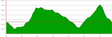
 This was the profile of the walk.
We were meant to have covered 6.8 miles, but the detour took us to about 8 miles. We climbed about 1012 feet across the route, raising to a maximum height of 717 feet, and dropping to 213 feet.
Another lovely walk. If you are interested in seeing more pictures from the walk, have a look at the set on flickr.
Good countryside, good company, good conversation. Thanks James.
[File under: SussexWalk, Washington West Sussex, Elbourne, Findon]

No comments:
Post a Comment